Thursday, 14 December 2017

Abaco, Bahamas


From Spanish Cay, we sailed to Green Turtle Cay, where we read there is a grocery store, and we walked around the little village of New Plymouth.


The water taxi to the mainland (Great Abaco Island)


Just to the southeast, was the famous No Name Cay, with it’s main attraction, Piggyville.  We had to visit. The island was fringed with beautiful white sand beaches, and was home to at least a dozen hairy pigs, and at least that many chickens. It was quite an attraction, as the boats arrived throughout the day to feed the “swimming pigs of Abaco”.


From No Name Cay, we transited the feared and treacherous Whale Cay Channel in order to get to the protection of Treasure Cay harbour. Treasure Cay has a crescent beach that is one of the World’s top ten! We caught one of the marina’s moorings and enjoyed benefits such as hot showers and use of their swimming pool. The beach was fantastic, and no one was there!


Next port of call was Marsh Harbour, which is a proper town with two grocery stores and lots of other shopping. We had a wonderful opportunity to visit a special education school called “Every Child Counts” that has a wonderful program that employs its own graduates that wouldn’t be able to find work otherwise. They supply local restaurants with pre-packaged cutlery and bar soap etc.  This school is not funded, so it has to raise its own money throughout the year.


One of the nice homes along the harbour front


It was here in Marsh Harbour that we found a replacement for the bi-colour navigation light we lost off our bow crossing from Charleston. We also purchased charts and guides for the planned Caribbean Sea crossing to Panama, and the South Pacific Islands.

Tim trying to pull down coconuts.


While anchored in Marsh Harbour, we listened to Christmas music over the radio, and were growing nostalgic of the beautiful Canadian Christmases with our family and friends.  We had nothing to purchase or wrap, so we made our own Christmas tree out of collected bits of driftwood and seashells!
Our Christmas Tree!
We also put up a string of lights in the rigging to pass on our cheer to others in the harbour! We miss everyone terribly. 

Merry Christmas, everyone!

Friday, 24 November 2017

Charleston, South Carolina


Wrightsville Beach was a great place to be, but we had to move south. One day we decided to do a long run down the coast, all the way to Charleston South Carolina. We both stayed up with a few cat naps here and there, and anchored in the Ashley River. The nearby Charleston City Marina was a safe place to leave the dinghy while we explored the historic city. One shocking sight as we anchored, were the boats beached from the remnants of hurricane Irma earlier this year, locals attributing the mishaps to be from poor anchoring for storm conditions.


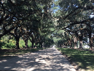
Charleston, S.C. was once home to one of the main slave markets in the southern United States, and it was here where the first shot of the American Civil War was fired. We visited the Boone Hall Plantation, where a mansion was preserved, along with a number of slave cabins, each portraying a different theme of slaves and their daily lives. This plantation was also used in Hollywood movies including Queen, North and South, and The Notebook.  Beautiful giant Live Oaks with Spanish moss lined the long driveway. On September 22, 1862, President Abraham Lincoln finally put and end to slavery in the United States, and declared that on January 1, 1863, all slaves would be freed. We felt terribly sad about the whole slavery thing, but were proud to be Canadians, from a country that was the final safe haven for runaway slaves through the “underground railroad”.
Live oaks and Spanish moss line the driveway to Boone Hall

Boone Hall

A few of the slave cabins - each housed two families

Tour guide of the Boone Hall Plantation, still a private residence.
Beautiful buildings line the streets in downtown Charleston

Historical plaque in downtown "Old Charleston"


From Charleston, we sailed 4 days to the Bahamas, Spanish Cay to be specific, in the northern Abacos Islands. It was a long tough sail, with favourable winds, but stronger than either of us liked, resulting in mountainous seas. It was hard sailing in the day with everything reefed, but much harder at night, when you couldn’t see a thing. Karen had packed a "goodie bag" filled with all sorts of delicious, easy to eat snacks, and it proved to be invaluable to keep us going through the worst of the passage. Needless to say, we were overjoyed to drop the hook in a sheltered anchorage and catch up on our sleep.
Flying the "Q" flag, awaiting entry into the Bahamas at Spanish Cay Marina

Karen at one of the beautiful beaches on Spanish Cay


We cleared customs at Spanish Cay Marina and enjoyed a day visiting several beautiful beaches, swimming in the pool and relaxing!

Monday, 30 October 2017

Chesapeake Bay and the ICW


After sitting in Cape May and Lewes waiting out the weather, we finally found a suitable weather window to travel up Delaware Bay and transit the Chesapeake Bay - Delaware River Canal, known by boaters everywhere as the “C&D Canal”. Delaware Bay is quite large, and has no anchorages or marinas for practically any kind of deep draft boats, especially sailboats, so it was tricky to get from one end to the other, but we managed to find a bumpy anchorage in Cohansey Cove. 
The next morning, we made it through the C&D Canal having timed the tides and currents to maximize our speed through the day, and anchored in the Sassafras River in Maryland. 
Hope Creek Nuclear Generating Station in Delaware Bay near the C&D Canal 
A mega-yacht transiting the C&D Canal with us.
The following day we found a marine store in Fredericktown up the river, and the store owner was kind enough to give us a ride into nearby Galena to buy some groceries, since the area had no taxis.


We continued down the Chesapeake to Magothy River, where we found a protected anchorage in the north side of Gibson Island to hide from a strong southwesterly blow coming. We slept well that night in flat waters.  The next morning, we took off with a nice breeze and had plans to put some miles behind us, but while making toast on the BBQ for breakfast, we ran out of propane, so our plans changed. We searched on the Internet and found a propane refill station in nearby Londontowne, just south of Annapolis, which was hosting the Annapolis Boat Show, and was jammed with boaters looking for room to dock, moor, anchor or just drive around and make people crazy…. Anyway, we found a safe anchorage and the nice people at the Londontowne Marina allowed us to leave our dinghy while we took a nice walk with all of our propane cylinders to the refill station, doubtful that we would only be less than an hour. Let me add that it was hot and humid that day, and the walk was up-hill for an hour. Ughh! Brutal would be a kind description of the hike, but we got the tanks filled, and cabbed back to the marina, set for another 4 months.

We felt this urgency to continue to move south, and while it was still hot here, much hotter than we’re used to back home, fall was coming, and there were signs everywhere: leaves turning colours, and flocks of birds of all kinds moving south – just like us, and the growing number of Canadian boats we were seeing.
A flock of Canada Geese heading south, maybe showing us the way?

We were picking our way down the Bay, planning each day where the next best anchorage would be, based on the forecast. Places like Solomons Island, Reedville, Deltaville, and Chisman Creek, outside of (maybe you’ve heard of it) Langley Air Force Base. A free air show!
jets flew by every minute or so...
Eventually getting to Norfolk at the very south end of the Chesapeake Bay, home of the USA’s Atlantic Fleet.  There was a lot of security here, so we felt safe.
The WWII Missouri moored outside of our anchorage in Norfolk, VA.

We left Norfolk to begin our trip down the Atlantic Intracoastal Waterway (ICW) on Friday the 13th of October, with an enormous degree of anxiety due to the legends of long keeled boats running aground on never-ending shifting sandbars and countless other shallow-water hazards.
The ICW is a connected series of navigable waterways along the southeastern USA's coast


As we travelled south, ecosystems change - here cypress swamps start to appear.
Well, we made it to Coinjock, North Carolina the first day, and East Lake at the mouth of the Alligator River the second, without mishap!

We have been plagued with low-battery power issues since the days had been growing shorter, and Tim found a loose wire on the alternator in Coinjock, and refreshed the engine ground, and for now the problem seems to have been corrected, but we are still thinking of a wind generator to provide power at night, or on cloudy days when we can’t expect much from the solar panels we have depended on for so long. We’ve also noticed that the days are growing shorter, so our solar gain on sunny days is barely enough to meet all of our electrical needs, and we aren’t running 24-hours a day on passages yet.
Sailboats sailing in Abelmarle Sound, part of the ICW.

Another glorious sunset!
We continued on down the ICW and made it to one of our potential jumping-off ports, Beaufort, North Carolina. Weather was fantastic, and it was like we were living in an endless summer!

Homes are scattered along the waterway, but now they have plam trees.

And Pelicans are everywhere!
We dinghied over to one of the many beaches outside of town and spent the day picking up littles seashells, one of my beach hobbies! 
One of the beautiful beaches near Beaufort, NC

Wild horses still wander the off-shore islands, today, we were lucky to see one!
We have seen many dolphins, but it was on one of these days, motoring down the ICW that we finally got a decent picture of one!
Dolphins swimming beside us in the ICW, and finally a decent picture!
We decided to continue moving south, as hurricane season wasn’t over yet, and ordered a wind turbine to be picked up a few days south in Wrightsville Beach NC, just east of Wilmington. We lined up a pole to mount the turbine on, and would spend a few days to install it.
Megalodon shark teeth on display (and for sale) at the Workshop gourmet sandwich shop in Wrightsville Beach

The Atlantic Ocean at Wrightsville Beach

Homes and boats along Banks Channel in Wrightsville Beach, NC

the path from our dinghy dock was just behind these buildings, literally steps to the beach!
Wrightsville Beach is a bustling little community with protected islands and watercourses inland, and a fantastic sandy stretch of the Atlantic Ocean! It was hot, so we had to check it out! The surf was wicked, and not many people were swimming, other than a bunch of crazy surfers who were having a blast!

Wrightsville Beach hurricane water level waning sign

Yet another storm brewing - the beginnings of Phillipe - one we'll also have to be wary of.

Anyway, we continue to watch the weather, and are trying to determine where to go after hurricane season; there has been so much destruction in the northeastern Caribbean, and many of the islands we planned to visit are going through hard times and rebuilding, and it would be unfair of us to visit them and consume their food, fuel and water.  We have some planning to do.

Thursday, 28 September 2017

New England (Part 2)


So we weathered the winds generated by hurricane Jose in the safe harbour of Port Jefferson, NY and put Vata back together, and sailed off to Oyster Bay, still on Long Island, New York.  Oyster Bay is home to America’s oldest yacht club.  It was also a pretty safe harbour, and we anchored well, so we went into town for a look around.  We found a nice little Italian-American grocery store, where we found some tasty lunchmeats and cheeses.


Oyster Bay Had a very historic downtown.

Also home of President Theodore Roosevelt...


The next day, we set off with high hopes of getting to College Point near LaGuardia Airport, but the timing to go further through the infamous “Hells Gate” on New York City’s East River was perfect with favourable tides and currents, so we went for it! 
Entering New York City from Long Island Sound, on the East River
As we approached the Hells Gate we were doing 10.6 knots! But all can’t be good: as we rounded the corner, Police and Coast Guard had installed a “Safety and Security Zone” on the west branch of the East River, the side with no bridges, but also the side with the UN Headquarters, and a meeting was in progress, and no one was allowed in the vicinity.  We called for a lift bridge to open, but the operator’s radio wasn’t working, so after two hours of calling on the radio, we managed to find the operator through the New York City’s 311 telephone service and the bridge opened. By then, 4 boats rushed to downtown Manhattan.
Roosevelt Island Lift Bridge is finally up!
The traffic was, well, busy! Between the police presence passing the UN Headquarters, there were ferries, ships, and many other boats, and everyone created such a chop on the water that we were racing through 4’ waves. We passed Battery Point, and made a bee line to the Statue of Liberty, dodging Staten Island Ferries and Liberty Island tour boats. Afterward, with the day growing long, we hurried on under the Gateway Bridge to anchor around the tip of Sandy Hook, New Jersey.  It turned out to be a very long day, but We enjoyed our first New Jersey sunset with cocktails, safely at anchor, with two other Canadian Boats!


The southern tip of Manhattan Island

The Statue of Liberty in New York Harbor

Anchored off Sandy Hook New Jersey, in time to enjoy the sunset.


The next morning, we made way for an anchorage inside Barnegat Inlet.  There was a remnant swell from Hurricane Jose, but it was on the beam, so sailing was good.  The New Jersey Shore was one endless sand beach! While underway we prepared a chili for supper, and it simmered on the gimballed stove top. We arrived at Barnegat Inlet near low tide, and it was our first experience entering an inlet. There was a strong current flowing against us, like rapids in a river, and the ocean swell rolled against the current creating steep breaking waves.  We watched a big fishing boat navigate the inlet ahead of us, gave the engine more power!  The rolling and pitching was wicked! I was at the wheel, so Karen carefully (yet quickly) climbed down below to rescue our dinner, and put the entire pot of chili in the galley sink where it wouldn’t spill. Inside the inlet it was like a calm lagoon, and we anchored nearby.
Barnegat Lighthouse at the inlet's entrance.


The next day, we moved further down the coast, and ended up anchoring in Atlantic City, surrounded with tall casino hotels. Wonderful sight at night!
Arriving in Atlantic City!

Two Atlantic City casino/hotels beside us, all lit up for the night.


On September 25, 2017, we set sail for Cape May Harbor, at the south end of New Jersey.  We anchored beside the Coast Guard Station. Meanwhile, Hurricane Maria was moving up the coast, and the wind forecast would not make for easy sailing, so we decided to stay put and wait for gentler winds.  Instead, we visited the town of Cape May, and her historic buildings, and provisioned, completed our second engine oil change of the summer, and enjoyed hot temperatures in the safety of the harbour.
Ushes Marina had an excellent marine supply store with great staff so we didn't have to use this...

Some of the historical buildings in downtown Cape May
"A Tiny Cruise Line" offers guided tours of the harbour and surrounding area.

The Acme Supermarket where we did our groceries.


Tomorrow, we’ll move on to Delaware Bay, but we still have to decide: go up the bay to the Chesapeake-Delaware Canal to Chesapeake Bay, or down the Coast to Virginia….