Monday, 30 October 2017

Chesapeake Bay and the ICW


After sitting in Cape May and Lewes waiting out the weather, we finally found a suitable weather window to travel up Delaware Bay and transit the Chesapeake Bay - Delaware River Canal, known by boaters everywhere as the “C&D Canal”. Delaware Bay is quite large, and has no anchorages or marinas for practically any kind of deep draft boats, especially sailboats, so it was tricky to get from one end to the other, but we managed to find a bumpy anchorage in Cohansey Cove. 
The next morning, we made it through the C&D Canal having timed the tides and currents to maximize our speed through the day, and anchored in the Sassafras River in Maryland. 
Hope Creek Nuclear Generating Station in Delaware Bay near the C&D Canal 
A mega-yacht transiting the C&D Canal with us.
The following day we found a marine store in Fredericktown up the river, and the store owner was kind enough to give us a ride into nearby Galena to buy some groceries, since the area had no taxis.


We continued down the Chesapeake to Magothy River, where we found a protected anchorage in the north side of Gibson Island to hide from a strong southwesterly blow coming. We slept well that night in flat waters.  The next morning, we took off with a nice breeze and had plans to put some miles behind us, but while making toast on the BBQ for breakfast, we ran out of propane, so our plans changed. We searched on the Internet and found a propane refill station in nearby Londontowne, just south of Annapolis, which was hosting the Annapolis Boat Show, and was jammed with boaters looking for room to dock, moor, anchor or just drive around and make people crazy…. Anyway, we found a safe anchorage and the nice people at the Londontowne Marina allowed us to leave our dinghy while we took a nice walk with all of our propane cylinders to the refill station, doubtful that we would only be less than an hour. Let me add that it was hot and humid that day, and the walk was up-hill for an hour. Ughh! Brutal would be a kind description of the hike, but we got the tanks filled, and cabbed back to the marina, set for another 4 months.

We felt this urgency to continue to move south, and while it was still hot here, much hotter than we’re used to back home, fall was coming, and there were signs everywhere: leaves turning colours, and flocks of birds of all kinds moving south – just like us, and the growing number of Canadian boats we were seeing.
A flock of Canada Geese heading south, maybe showing us the way?

We were picking our way down the Bay, planning each day where the next best anchorage would be, based on the forecast. Places like Solomons Island, Reedville, Deltaville, and Chisman Creek, outside of (maybe you’ve heard of it) Langley Air Force Base. A free air show!
jets flew by every minute or so...
Eventually getting to Norfolk at the very south end of the Chesapeake Bay, home of the USA’s Atlantic Fleet.  There was a lot of security here, so we felt safe.
The WWII Missouri moored outside of our anchorage in Norfolk, VA.

We left Norfolk to begin our trip down the Atlantic Intracoastal Waterway (ICW) on Friday the 13th of October, with an enormous degree of anxiety due to the legends of long keeled boats running aground on never-ending shifting sandbars and countless other shallow-water hazards.
The ICW is a connected series of navigable waterways along the southeastern USA's coast


As we travelled south, ecosystems change - here cypress swamps start to appear.
Well, we made it to Coinjock, North Carolina the first day, and East Lake at the mouth of the Alligator River the second, without mishap!

We have been plagued with low-battery power issues since the days had been growing shorter, and Tim found a loose wire on the alternator in Coinjock, and refreshed the engine ground, and for now the problem seems to have been corrected, but we are still thinking of a wind generator to provide power at night, or on cloudy days when we can’t expect much from the solar panels we have depended on for so long. We’ve also noticed that the days are growing shorter, so our solar gain on sunny days is barely enough to meet all of our electrical needs, and we aren’t running 24-hours a day on passages yet.
Sailboats sailing in Abelmarle Sound, part of the ICW.

Another glorious sunset!
We continued on down the ICW and made it to one of our potential jumping-off ports, Beaufort, North Carolina. Weather was fantastic, and it was like we were living in an endless summer!

Homes are scattered along the waterway, but now they have plam trees.

And Pelicans are everywhere!
We dinghied over to one of the many beaches outside of town and spent the day picking up littles seashells, one of my beach hobbies! 
One of the beautiful beaches near Beaufort, NC

Wild horses still wander the off-shore islands, today, we were lucky to see one!
We have seen many dolphins, but it was on one of these days, motoring down the ICW that we finally got a decent picture of one!
Dolphins swimming beside us in the ICW, and finally a decent picture!
We decided to continue moving south, as hurricane season wasn’t over yet, and ordered a wind turbine to be picked up a few days south in Wrightsville Beach NC, just east of Wilmington. We lined up a pole to mount the turbine on, and would spend a few days to install it.
Megalodon shark teeth on display (and for sale) at the Workshop gourmet sandwich shop in Wrightsville Beach

The Atlantic Ocean at Wrightsville Beach

Homes and boats along Banks Channel in Wrightsville Beach, NC

the path from our dinghy dock was just behind these buildings, literally steps to the beach!
Wrightsville Beach is a bustling little community with protected islands and watercourses inland, and a fantastic sandy stretch of the Atlantic Ocean! It was hot, so we had to check it out! The surf was wicked, and not many people were swimming, other than a bunch of crazy surfers who were having a blast!

Wrightsville Beach hurricane water level waning sign

Yet another storm brewing - the beginnings of Phillipe - one we'll also have to be wary of.

Anyway, we continue to watch the weather, and are trying to determine where to go after hurricane season; there has been so much destruction in the northeastern Caribbean, and many of the islands we planned to visit are going through hard times and rebuilding, and it would be unfair of us to visit them and consume their food, fuel and water.  We have some planning to do.

Thursday, 28 September 2017

New England (Part 2)


So we weathered the winds generated by hurricane Jose in the safe harbour of Port Jefferson, NY and put Vata back together, and sailed off to Oyster Bay, still on Long Island, New York.  Oyster Bay is home to America’s oldest yacht club.  It was also a pretty safe harbour, and we anchored well, so we went into town for a look around.  We found a nice little Italian-American grocery store, where we found some tasty lunchmeats and cheeses.


Oyster Bay Had a very historic downtown.

Also home of President Theodore Roosevelt...


The next day, we set off with high hopes of getting to College Point near LaGuardia Airport, but the timing to go further through the infamous “Hells Gate” on New York City’s East River was perfect with favourable tides and currents, so we went for it! 
Entering New York City from Long Island Sound, on the East River
As we approached the Hells Gate we were doing 10.6 knots! But all can’t be good: as we rounded the corner, Police and Coast Guard had installed a “Safety and Security Zone” on the west branch of the East River, the side with no bridges, but also the side with the UN Headquarters, and a meeting was in progress, and no one was allowed in the vicinity.  We called for a lift bridge to open, but the operator’s radio wasn’t working, so after two hours of calling on the radio, we managed to find the operator through the New York City’s 311 telephone service and the bridge opened. By then, 4 boats rushed to downtown Manhattan.
Roosevelt Island Lift Bridge is finally up!
The traffic was, well, busy! Between the police presence passing the UN Headquarters, there were ferries, ships, and many other boats, and everyone created such a chop on the water that we were racing through 4’ waves. We passed Battery Point, and made a bee line to the Statue of Liberty, dodging Staten Island Ferries and Liberty Island tour boats. Afterward, with the day growing long, we hurried on under the Gateway Bridge to anchor around the tip of Sandy Hook, New Jersey.  It turned out to be a very long day, but We enjoyed our first New Jersey sunset with cocktails, safely at anchor, with two other Canadian Boats!


The southern tip of Manhattan Island

The Statue of Liberty in New York Harbor

Anchored off Sandy Hook New Jersey, in time to enjoy the sunset.


The next morning, we made way for an anchorage inside Barnegat Inlet.  There was a remnant swell from Hurricane Jose, but it was on the beam, so sailing was good.  The New Jersey Shore was one endless sand beach! While underway we prepared a chili for supper, and it simmered on the gimballed stove top. We arrived at Barnegat Inlet near low tide, and it was our first experience entering an inlet. There was a strong current flowing against us, like rapids in a river, and the ocean swell rolled against the current creating steep breaking waves.  We watched a big fishing boat navigate the inlet ahead of us, gave the engine more power!  The rolling and pitching was wicked! I was at the wheel, so Karen carefully (yet quickly) climbed down below to rescue our dinner, and put the entire pot of chili in the galley sink where it wouldn’t spill. Inside the inlet it was like a calm lagoon, and we anchored nearby.
Barnegat Lighthouse at the inlet's entrance.


The next day, we moved further down the coast, and ended up anchoring in Atlantic City, surrounded with tall casino hotels. Wonderful sight at night!
Arriving in Atlantic City!

Two Atlantic City casino/hotels beside us, all lit up for the night.


On September 25, 2017, we set sail for Cape May Harbor, at the south end of New Jersey.  We anchored beside the Coast Guard Station. Meanwhile, Hurricane Maria was moving up the coast, and the wind forecast would not make for easy sailing, so we decided to stay put and wait for gentler winds.  Instead, we visited the town of Cape May, and her historic buildings, and provisioned, completed our second engine oil change of the summer, and enjoyed hot temperatures in the safety of the harbour.
Ushes Marina had an excellent marine supply store with great staff so we didn't have to use this...

Some of the historical buildings in downtown Cape May
"A Tiny Cruise Line" offers guided tours of the harbour and surrounding area.

The Acme Supermarket where we did our groceries.


Tomorrow, we’ll move on to Delaware Bay, but we still have to decide: go up the bay to the Chesapeake-Delaware Canal to Chesapeake Bay, or down the Coast to Virginia….

Tuesday, 19 September 2017

New England


Maine was a huge State, and it ended up taking longer than intended to get across it. Our last stop would be in Kittery, where we lucked out and found an excellent deli on Route 1, a mere ½ hour walk from our dinghy where we found delicious meats, and a next-door grocer with abundant and affordable produce.

We left Kittery, Maine, with a mission to get to Long Island, New York, so, we picked up the pace, with favourable winds. 

Most of you guys have no idea what that means… but it’s hard to sail against the wind. That’s why the traditional sailing routes went from Europe to off-shore Africa, to the Caribbean, northerly along the east coast of North America then back across the Atlantic to Europe. A great big circle!

To make a long story short, we were going against the prevailing southwesterly summer winds, so when the winds were in our favour, we went! Fortunately, as the leaves start to turn colour the winds start to swing a bit more westerly to north-westerly, which makes for a great sail down the east coast.
So we left Kittery, Maine, and sailed past the entire shoreline of New Hampshire, before setting the hook in Wood Island Harbor, Massachusetts. The next day, we stayed because the forcasted weather wasn’t good, an instead we took care of several chores.

When the forcast improved, we sailed to Gloucester, Massachusetts, an old harbour, but made famous in the movie “The Perfect Storm” starring George Clooney. It was a very busy harbour due to the number of fishing boats there, and they like to leave throughout the night instead of sleeping like sailors like to do.

The next day we had fantastic winds again and sailed to Provincetown, Massachusetts, on the very tip of Cape Cod.  If you have never been there, it is worth a trip to P’Town as the locals call it.  A very colourful town bustling with people, and stores and restaurants for everyone.

 
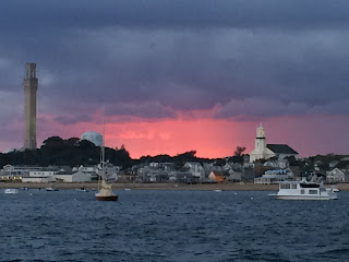
Provincetown, MA at sunset, with the tall Pilgrim Monument marking their first landfall in the new world.

In P’Town we consulted the tide tables for the next leg, Cape Cod Bay and the Cape Cod Canal. It is important to enter the canal when tides are slack or running in the direction you are going. Interesting to note, that on Cape Cod Bay the tidal range is 10 feet, whereas on Buzzards Bay, the tidal range is 4 feet.  So halfway to high tide the water in the canal starts to flow toward Buzzards Bay, and the current increases every hour, to 4 knots. The next day we sailed to the canal and caught it 1 hour before high tide. Nearing the canal, we were making 6 knots motoring, and 50 minutes later we shot into Buzzards Bay doing 10.1 knots! We anchored in quiet Mattapoisett Bay an hour later.

 
Flying through the Cape Cod Canal!

Winds still favourable, we left Mattapoisett Harbor early, and sailed past Newport Rhode Island, all the way to Judith Point.  At one point, I heard a huge swish sound behind Vata, and I turned around to see a humpback whale surface!  At Judith Point, they built a large breakwater enclosing an outer harbour here many years ago, and called it a “Harbor of Refuge”. Well it was very lumpy in there overnight, and I don’t think the breakwater would do much to keep a hurricane’s storm surge out. 

In any case, we are starting to recognize the names of boats we see, and often can’t remember where we saw them before, because we didn’t keep track. But, it seems that we are all geese starting to flock together on the migration south!

On September 11, 2017, the winds were once again in our favour, and we sailed from Point Judith nearly all the way to Orient Harbour, located on the very eastern tip of Long Island’s North Fork, motoring for the last bit of the day’s run. So close to New York City, we remembered the terrible events of 9-11, 16 years prior.
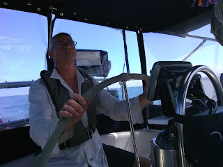
 
Tim at the helm

The next day, against an ebbing tide, we motored for 3 hours and anchored in Cutchogue Harbour, neatly tucked into a relatively small protected bay, where we would visit with my brother for a few days. The employees at New Suffolk Shipyard were accommodating and allowed us to leave our dinghy there fore our duration.

We had several days of seeing the area and completing some heavy provisioning. Then we took 
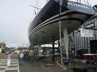
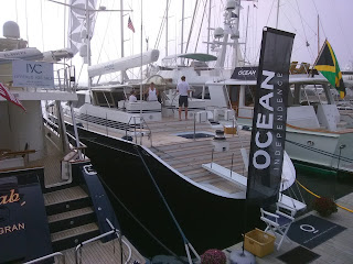
the “Orient - New London” ferry and went to the Newport Boat Show! The best part was the floating display of boats!!  We even toured a huge sailboat for sale that had a hot tub and a crew of 4! People in Newport definitely have a passion for boats!

 
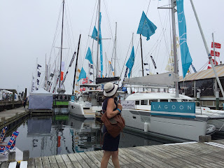
Newport Boat Show is an "on-the-water" show

One of the mega-sailboats we saw in Newport

We toured this $4 million yacht, complete with a hot tub!!

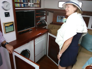
So Tim, we NEED a washer and drier on our boat too!
Afterwards, we found time to tour the summer cottages of old in Newport, owned by people like the Vanderbilts… well, they were grand!  Much more cottage than we’re used to at home.
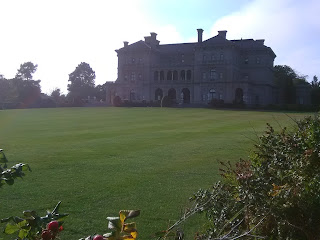
The Vanderbilt's summer "cottage"


Before leaving Long Island, we had to taste some of their famous wines.
wine tastings at Mattabella Vineyards! Thank you Christine and Mark for your great hospitality!
Most harbours are a wake-free zone, but some people don't comply...


Hurricane Jose was kicking up a fuss in the Atlantic Ocean well to the south of us, but threatening to move closer, so it is time to move on to a safer place.  We sailed north to the Connecticut River one day, then east to New Haven, opting for a turn to the south and a safe harbour of Port Jefferson. And we spent a day tearing down the boat to prepare for Hurricane Jose.
Arriving in Port Jefferson, NY

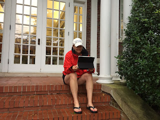
Karen talking to the kids with the Library's free Wi-Fi.

As we were preparing Vata for storm conditions, these swans came by to say hello. An Omen?
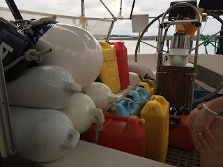
Everything stripped off the deck to reduce windage - and now we wait!