Pacific Part 1
includes leaving Panama and the long sail to the Marquesas Islands, the first
island group of French Polynesia.
---------------------------------
We left Panama
City and the Balbao Yacht Club with their daily fees behind us and anchored at
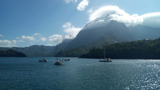
Playita, but the water was very filthy. The next morning, we sailed to Taboga
Island to find a cleaner and much more relaxing environment.
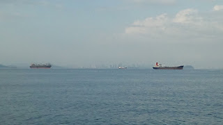 |
| Many, many ships anchored on the Pacific side of the Panama Canal, waiting to either transit or to provision before continuing on the Pacific Ocean. |
We left there
the following morning and crossed to the Las Perlas Islands, where we learned a
Survivor TV show was filmed. We anchored between Islas La Chaplera and Mogo
Mogo. Several other boats were also anchored there, obviously a popular spot.
We dinghied over to, and walked the beautiful Survivor Beach.
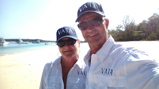 |
| Karen and Tim on Survivor Beach |
The Next stop
was Isla Jose Gonzales, where we picked a quiet anchorage and found 8 local
fishing boats rafted together, waiting for their nearby nets to fill with fish.
Here we also found a long coconut palm-fringed crescent beach, where we went
for a long walk, knowing it would be a long time before we walked on land
again. Signs on the trees along shore indicated the site was reserved for a
future Ritz Carleton hotel development. During our walk, the beach was
deserted. In the afternoon, we deflated the dinghy and completely disassembled
it, bundled it up and secured it to the deck in preparation for the long 30-day
ocean crossing to the Marquesas Islands. We reflected on our brief time in
Panama; a pretty country with lots of birds everywhere, likely an indication of
a healthy ecosystem and rich biodiversity.
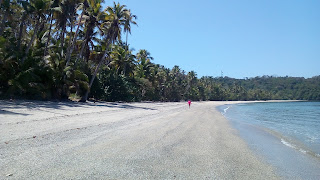 |
| Ritz Carleton Beach |
On Monday,
February 25, 2018, we raised the anchor, and pointed Vata west toward Hiva Oa
in the Marquesas Islands, some 3,744 nautical miles away! It took all of that
day, and the next until we finally lost sight of the Panamanian mountains. And
once again, we were surrounded by nothing but ocean!
We worked out a
watch system that works for us, so that one of us is always looking for other
boats, ships and hazards. At night only, we do 3 hours on, 3 hours off. At 6
p.m. Karen is on watch, and Tim has an evening nap, until 9; then switch till
midnight, then back till 3 a.m., then switch till 6 am. Tim normally sleeps for
another hour or two in the morning before we get on with our daytime routine.
Getting to the
South Pacific means sooner or later one must cross the Equator. For mariners, it is a significant event and
therefore requires a ceremony. As we crossed the Equator we were paid a
surprise visit by King Neptune, God of the Seas. We paid homages to him, and the
Gods of the Winds, and all our guardian angels watching over us.
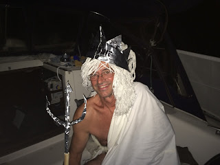 |
| King Neptune! (It's the best I could do in the middle of the ocean) |
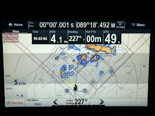 |
| Just crossed the Equator, with the Galapagos Islands ahead. |
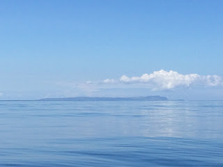
Although we
left Panama with a Zarpe (clearance certificate) indicating a direct passage to
the Marquesas, our track would take us right through the Galapagos Islands. On
Monday, March 5th we caught our first glimpses of Isla San Christobal
of the Archipelago de Colon (Galapagos Islands), named after the famous
navigator and explorer “Christobal Colon”.
So many places (throughout the
Spanish Americas) have been named after this man who was hired by the Spanish
Crown to find a shorter route to India, and failed. In English, we know him as
Christopher Columbus. He never visited these islands, but the bishop who
accidentally found this uninhabited archipelago named them after him.
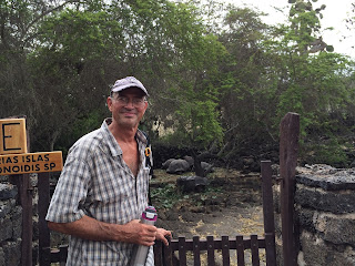
After seeing
hundreds of sea turtles and seals, we made an unscheduled stop to top up with
gasoline, diesel water and fresh fruits. We entered the Galapagos in Puerto
Ayora on Isla Santa Cruz. Puerto Ayora is the most populated settlement in the
Galapagos, and centre for tourism in the island group. Entry into the Galapagos
is tricky, and for sailors can only be accomplished through an “agent”. After
securing an agent, a group of officials visited Vata before entry could be
granted. A boat load of people showed up, most in different uniforms: customs,
immigration, police, Navy, National Park staff, scuba divers to check the boat
bottom, agriculture with vacuum cleaners to check for insects… there was no
room for us to sit anywhere.
 |
| Isla San Christobal |
 |
| Isla Santa Cruz |
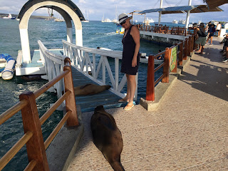 |
| Puerto Ayora water taxi dock |
 |
| This is the best way to get from your boat to town! $1.00 per ride, and no seals to shoo off your dinghy. |
 |
| Seals make themselves at home. |
We explored the
town and checked out their stores and markets and found supplies in
out-of-the-way places that allowed us to see how people here live. Close to our
agent’s office was an after school English program and Karen was invited in to
speak to the kids, and the children asked her questions in English – she had
fun!
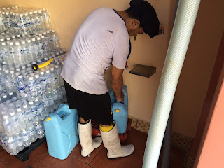 |
| Galapagos Reverso Osmosis water to fill our tanks! |
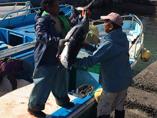 |
| Local fishermen bringing in their catch of tuna! |
One cannot
think of the Galapagos without Charles Darwin in mind. Darwin visited these
islands in 1835 on the Beagle, and it was here that he saw unique species
adapting and evolving in isolation which helped him develop his controversial
and revolutionary Theory of Evolution. Ironically, he never set foot on Isla
Santa Cruz. Before his visit and afterwards, however, ships would stop here to fill
their holds with giant tortoises for meat, and with good intentions they
populated the islands with cattle, goats and pigs for future use. With the incidental introduction of rats on
top of this, the introductions spelled doom for the tortoises, as not only was their
food eaten, but their eggs too. In 1950
the Galapagos was made a National Park in Ecuador, and on September 8, 1978,
UNESCO declared the Galapagos a Natural Heritage Site.
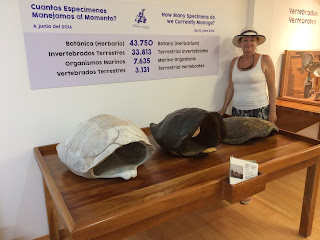
So, it is quite appropriate that on the outskirts of Puerto Ayora, we found the Charles Darwin Research Institute, where research on the biology of the islands continues, and part of the facility is a breeding centre for the giant tortoises. The tortoises from different islands, each unique, are being bred in captivity to improve their populations and avoid extinction.
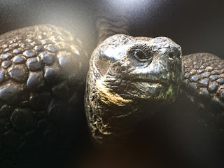
And this brings me to the touching story of Lonesome George, a tortoise who died on June 24, 2012, estimated to be between 120 and 130 years old. He was the last of his kind and his species is now extinct. A book about Lonesome George is available at many libraries and bookstores, and a free e-book is available for download at www.galapagos.org/george . “Let him always remind us that the fate of all living things is in human hands.”
 |
| Karen in the Darwin Research Centre |
 |
| Lonesome George |
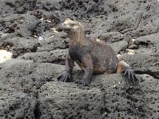 |
| An iguana on Lava |
 |
| Tim outside one on the breeding pens for the tortoises |
We left the
Galapagos and continued the long trek to the Marquesas. We joined a couple of
other sailboats and agreed to exchange e-mails every morning with our position,
weather information, and anything else of importance. Sailing was beautiful! 15-20
knots of southeast wind day and night. We were sailing between 6 and 8,5 knots
in the South Equatorial Current, which with the wind, pushes us to the
Marquesas. We saw no boats for days on end. Beautiful!
We are never
bored at sea. There is so much to do all the time, plus with the action of wind
and waves rocking and pitching the boat, everything takes longer. So, there’s
breakfast prep, cooking, and cleanup. Then we get on with our priority chores
or repairs for the day, anything from routine preventative inspections of
batteries, water systems, engine, rigging, etc., to fixing navigation lights,
alternators, cleaning the interior teak, to baking bread. Somewhere in there we
find time for lunch, and later dinner, and the day is gone. We also found that
its much easier to have our big meal at lunch (1-2 p.m.) because there is more
required for prep and cleanup, and its easier to do it with better light. So,
there you have it: a day in the life at sea…
If you have a
romantic image of sailing the southern seas and visiting exotic islands, lounging
around the yacht in your crisp whites, it hasn’t found this boat yet. The
reality is that we are sailing with limited water supplies, limited
electricity, limited fuel, limited space, and lets not forget a limited budget.
We enjoy few of the modern conveniences we took for granted at home. Recently, we found that our batteries were
not being charged, and at first thought it was because the sails were shading
the solar panels. Then the wind wasn’t strong enough to maximize the benefit of
the wind generator. Then we found the alternator on the engine was shot, and
there was no way to excite it into charging. Next, the generator wouldn’t
charge. When the batteries run low,
things start to shut down. In the end, we are hand steering in 15-20 knots of
wind in the middle of the night – pitch black - trying to stay on course not to
prolong this…hoping the sun will shine on our solar panels early in the
morning!
Then, on March
24th at 2 a.m. with just under 1000 nautical miles to go to Hiva Oa,
the unthinkable happened: we lost our steering. A warning suddenly sounded on
the chart plotter, and we veered off course; the boat turned to the wind and
headed back toward South America. We tried several things and nothing worked –
apparently, we lost our rudder. A home-made one was quickly built out of a piece
of plywood covering a water tank and the whisker pole, tied to the pushpit, and
under much reduced sail we struggled on. In the morning, I climbed down the
transom ladder with the GoPro and filmed in the crystal-clear water. The
evidence was undeniable: our rudder was completely gone. We emailed the other
sailors of our situation and advice and support rolled in. We built a drogue
and trailed it behind to assist in steering, and slowly got back on course.
What had been close to one week left on the passage to the Marquesas, would now
take us 2, 3, maybe 4 weeks. Extra.
On Good Friday,
a Catana 471 catamaran out of Vancouver, Element, found us, and gave us a tow!
Thank you, Shawn and Sherrie! On board they had their two daughters and guest
sailors from Germany. This wasn’t just a short tow around the corner. They were
headed to Hiva Oa, and we heard facilities were better in Nuka Hiva, and the
bay there was more protected and larger, so it would be safer for us, a
disabled vessel. So they changed their course and towed us 725 nautical miles!
Our first
towing bridle chafed through in a matter of hours. Our brand new 5/8” nylon
anchor rode…gone. Using what was left with fire hose for chafe protection got
us through that first night. Meanwhile we ran another piece and a 2,500 lb
polyester tow line from Sling Choker through another long piece of fire hose
for total chafe protection. I swapped the lines in the second morning, just in
time, before the other lines chafed through.
This double line held. I would crawl forward about every 4 hours for a
chafe inspection, and move the line a few centimeters from their cleated
position so the polishing on the fire hose didn’t become chafe. Eventually these lines chaed through, and had to be replaced. $ seats of tow lines were needed to reach Atuona, Hiva Oa.
 |
| building a drogue out of 2"x4". rope anchors, chain and a gas can filled with water. |
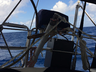 |
| Jury-rigged rudder |
 |
| Sv Element towing us to the Marquesas! Twin head sails, wing on wing |
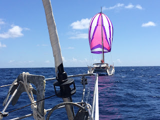 |
| Sv Element towing Vata under spinnaker. |
And what a sight it was! LAND HO! We made it!
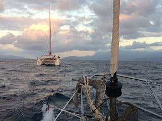 |
| At dawn, Hiva Oa in sight - what a relief!! |
 |
| And we anchored outside of Atuona, Hiva Oa, Marquesas Islands! |


